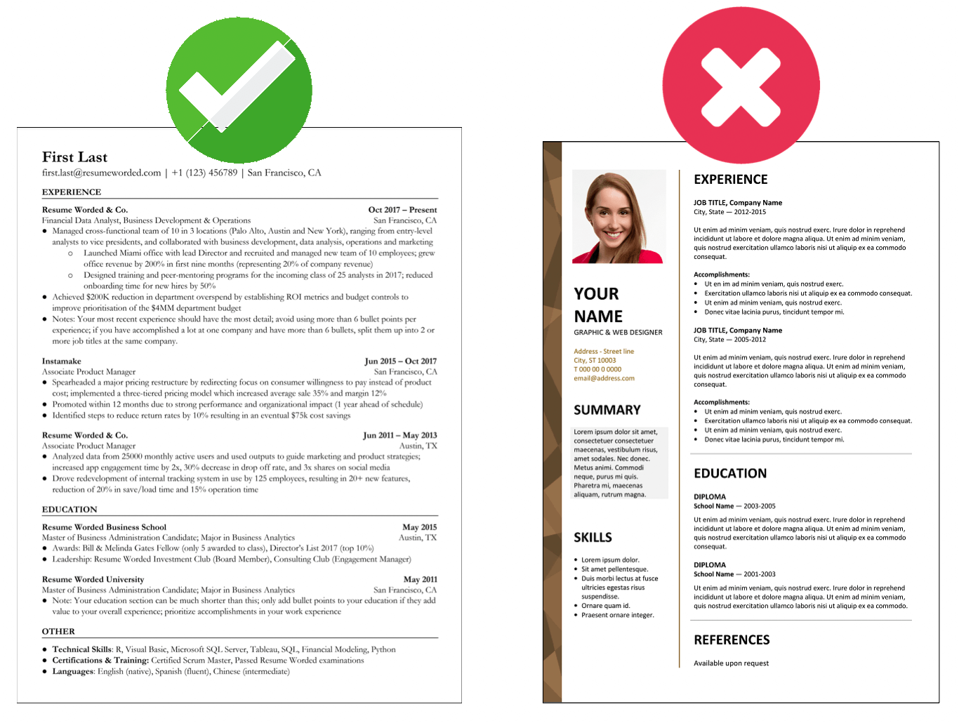
Geospatial Analyst

Geospatial Analyst Resume Keywords and Skills (Hard Skills)

Here are the keywords and skills that appear most frequently on recent Geospatial Analyst job postings. In other words, these are the most sought after skills by recruiters and hiring managers. Go to Sample Templates ↓ below to see how to include them on your resume.

Remember that every job is different. Instead of including all keywords on your resume, identify those that are most relevant to the job you're applying to. Use the free Targeted Resume tool to help with this.

Choose a category
  • Geospatial Intelligence
  • Imagery Analysis
  • Geographic Information Systems (GIS)
  • ArcGIS Products
  • Remote Sensing
  • Geospatial Data
  • ESRI
  •  Find out what your resume's missing
  • ArcMap
  • Spatial Analysis
  • Cartography
  • Intelligence Analysis
  • Geomatics
  • ERDAS Imagine
  • Geography
  • Google Earth
  • LiDAR
  • FMV
  • Intelligence
  • Military Operations
  • Socet Set

  •   Show full list

Resume Skills: Software

  • ArcGIS
  • QGIS
  • ERDAS Imagine
  • MapInfo Professional
  • GeoServer
  • ENVI
  • ERDAS IMAGINE
  • MapInfo
  • GeoMedia
  • IDRISI
  • AutoCAD
  • Python
  • SQL
  • HTML/CSS
  • JavaScript
  • Leaflet
  • OpenLayers
  • R
  • MATLAB
  • Python (Arcpy, Geopandas)
  • Java
  • Matlab
  • Microstation
  •  Match your resume to these skills

Resume Skills: Geospatial Analysis

  • ArcGIS
  • QGIS
  • ERDAS Imagine
  • MapInfo Professional
  • GeoServer
  • MapInfo
  • GeoMedia
  • ENVI
  • IDRISI
  • AutoCAD
  • GRASS GIS
  • CARTO
  • Mapbox
  • Spatial Analysis
  • Georeferencing
  •  Match your resume to these skills

Resume Skills: Programming

  • Python
  • SQL
  • HTML/CSS
  • JavaScript
  • Leaflet
  • OpenLayers
  • R
  • MATLAB
  • ENVI
  • Python (GeoPandas, rasterio)
  • Python (GeoPandas, Shapely)
  • Python (GeoPandas, Shapely, Folium)
  • R (RStoolbox, raster, sp, maptools, rgdal, rgeos, gdalUtils)
  •  Match your resume to these skills

Resume Skills: Data Visualization

Resume Skills: Spatial Databases

Resume Skills: Remote Sensing Programs

Resume Skills: Geographic Information Systems

Resume Skills: Remote Sensing

  • LiDAR
  • SAR
  • Aerial Photography
  • Multispectral Imagery
  • Drone Capture
  • Satellite Imagery
  • Remote Sensing Principles
  • Image Processing
  • LIDAR
  • Photogrammetry
  • Satellite Imagery Interpretation
  •  Match your resume to these skills

Resume Skills: Geospatial Technologies

Resume Skills: Data Management

Resume Skills: Data Science

Resume Skills: Satellite Imagery Interpretation

Resume Skills: Databases and Cloud Services

  Does your resume contain all the right skills? Paste in your resume in the AI Resume Scan ↓ section below and get an instant score.

Compare Your Resume To These Geospatial Analyst Skills (ATS Scan)

Paste your resume below and our AI will identify which keywords are missing from your resume from the list above (and what you need to include). Including the right keywords will help you get past Applicant Tracking Systems (i.e. resume screeners) which may scan your resume for keywords to see if you're a match for the job.

Sample Geospatial Analyst Resume Examples: How To Include These Skills

Add keywords directly into your resume's work experiences, education or Skills section, like we've shown in the examples below. Use the examples below as inspiration.

Choose a template
Your Name
Geospatial Analyst
City, Country  •  (123) 456-789  •  [email protected]  •  linkedin.com/in/your-profile
EXPERIENCE
Coached.com July 2019 - Present
Senior Geospatial Analyst
Incorporated Geospatial Intelligence and Spatial Analysis methods to enhance the predictive analytical model, resulting in 25% increase in operational efficiency
Led a team of junior analysts and standardized the use of ArcGIS and ESRI products, improving team productivity by 30%
Developed an innovative approach of combining LiDAR technology with traditional Geospatial Data, leading to quicker and more accurate analysis
Resume Worded January 2016 - June 2019
Geospatial Analyst
Demonstrated expertise in Imagery Analysis, enriching interactive maps with user-friendly features, boosting user experience by 35%
Implemented Remote Sensing techniques for spatial data collection resulting in increased coverage by 45%
Created informative Geographic Information Systems (GIS) reports, assisting other departments to understand trends and patterns
Esri June 2014 - December 2015
Junior Geospatial Analyst
Applied Cartography skills to develop 50+ detailed maps for internal and external stakeholders
Successfully manipulated geospatial data using ERDAS Imagine software for various projects
EDUCATION
Resume Worded University June 2019
Master's in Geospatial Information Systems
GPA: 3.8/4.0
Resume Worded Academic Center May 2014
Certification in Geospatial Analyst
Completed with distinction, in the top 10% of the class
SKILLS
Geospatial Analysis Tools: ArcGIS, QGIS, MapInfo, GeoMedia, ENVI, IDRISI, AutoCAD
Programming: Python (GeoPandas, Shapely, Folium), R (RStoolbox, raster, sp, maptools, rgdal, rgeos, gdalUtils)
Satellite Imagery Interpretation: IKONOS, QuickBird, GeoEye-1, WorldView-3, Landsat, Pleiades, Sentinel
Databases and Cloud Services: PostgreSQL, PostGIS, GeoServer, AWS, Google Earth Engine
OTHER
Certifications: Advanced Geospatial Analytics Certificate, Coursera (2020)
Projects: Developed a Geo-Spatial Application for Urban Planning leading to improved efficiency by 40%
Leadership & Volunteering: Led Geospatial Analysis workshops at local high schools, introducing GIS to over 300 students
Publications: Published 6 research papers on Spatial Analysis in peer-reviewed journals
Your Name
Geospatial Intelligence Analyst
City, Country  •  (123) 456-789  •  [email protected]  •  linkedin.com/in/your-profile
EXPERIENCE
Coached.com October 2017 - Present
Lead Geospatial Intelligence Analyst
Directed a team of Geospatial Analysts, resulting in the optimization of Intelligence Analysis strategies and a 40% increase in project completion rate
Utilized advanced ERDAS Imagine and Socet Set capabilities to provide critical location intelligence for high-stakes military operations
Played a key role in the development of a geospatial machine learning algorithm, leveraging Google Earth and ArcMap, leading to a 30% improvement in predictive accuracy
Resume Worded April 2014 - September 2017
Geospatial Intelligence Analyst
Spearheaded the integration of LiDAR data with GIS, achieving a 20% rise in data accuracy
Streamlined imagery analysis process by implementing new software tools, enhancing productivity by 35%
Leveraged geospatial intelligence to inform decision-making on key infrastructure projects, resulting in notable cost and time savings
EDUCATION
Resume Worded Academic Center September 2012 - July 2014
Master of Science in Geoinformatics
Award: Resume Worded Academic Excellence Award 2014 (Top 5% in class)
Resume Worded University August 2008 - June 2012
Bachelor of Engineering in Geospatial Technology
Minors in Remote Sensing and Computer Science
Achievements: First Place in University Level 'Spatial Challenge' Mapping Competition
SKILLS
Geospatial Analysis: ArcGIS, QGIS, ERDAS Imagine, ENVI, Spatial Analysis, Georeferencing
Software: Python (Arcpy, Geopandas), SQL, Java, Matlab, Microstation
Data Science: Machine Learning, Data Mining, Data Visualization, R, TensorFlow
Remote Sensing: Remote Sensing Principles, Image Processing, LIDAR, Photogrammetry, Satellite Imagery Interpretation
OTHER
Certifications: Esri Certified ArcGIS Desktop Professional, Certified Photogrammetry Professional
Projects: Developed georeferenced augmented reality tour application for local national park as part of a team project
Publications: Co-author of research paper titled 'Geospatial Analytics for Urban Planning' published in GeoWorld Journal
Leadership & Volunteering: Mentor at GeoMentors, an American Association of Geographers initiative for GIS learning, 2016-Present
Your Name
GIS Analyst
City, Country  •  (123) 456-789  •  [email protected]  •  linkedin.com/in/your-profile
EXPERIENCE
Coached.com May 2018 - Present
Senior GIS Analyst
Combined Cartography and Geomatics to optimize mapping processes, resulting in a 50% increase in project delivery speed
Led a significant data standardization project within GIS, streamlining workflows and improving efficiency across the department by 30%
Initiated the use of ArcGIS products to enhance the accuracy of remote sensing processes, elevating the precision of geospatial data by 40%
Resume Worded February 2014 - April 2018
GIS Analyst
Pioneered a new approach to geographic data visualization using Google earth, improving data interpretation for stakeholders
Managed large datasets using Spatial Analysis and GIS, leading to a 20% improvement in data management efficiency
Utilized ERDAS Imagine for advanced image processing, significantly improving the quality and accuracy of output images
EDUCATION
Resume Worded Academic Center January 2014
Master of Science - Geographic Information Systems
Thesis: 'Geospatial Analysis for Urban Development Planning'
Resume Worded University May 2012
Bachelor of Science - Geography
Award: Top Student in Remote Sensing and Geospatial Analysis
Part-time commitment while working full-time at Resume Worded
SKILLS
Geospatial Software: ArcGIS, QGIS, ERDAS Imagine, MapInfo Professional, GeoServer
Programming & Web Mapping: Python, SQL, HTML/CSS, JavaScript, Leaflet, OpenLayers
Spatial Databases: PostgreSQL/PostGIS, Oracle Spatial, MySQL, SpatialLite
Remote Sensing Programs: ENVI, Pix4D, Drone2Map, SARscape
OTHER
Certifications: ESRI Technical Certification: ArcGIS Desktop Associate (2020), Certificate in Geospatial Analysis and Visualization (2015)
Volunteering: Mapping and Spatial Data Analysis - Red Cross Disaster Response Team
Projects: Developed an interactive map for a local non-profit to visualize their impact across the city.
Awards: Employee of the Year - Coached.com (2020), GIS Leadership Award - Resume Worded (2017)

How do I add skills to a Geospatial Analyst resume?

1
Review the job posting closely.

Go through the Geospatial Analyst posting you're applying to, and identify hard skills the company is looking for. For example, skills like Geospatial Intelligence, Imagery Analysis and Geographic Information Systems (GIS) are possible skills. These are skills you should try to include on your resume.

2
Add industry skills like Geospatial Data and ArcMap.

Add other common skills from your industry - such as ArcGIS Products, Remote Sensing and ESRI - into your resume if they're relevant.

3
Add skills into your work experience.

Incorporate skills - like FMV, Intelligence Analysis and LiDAR - into your work experience too. This shows hiring managers that you have practical experience with these tools, techniques and skills.

4
Emphasize your ability to solve problems.

Recruiters want to know that you're the kind of person that can solve new and challenging problems. In your Geospatial Analyst resume, highlight projects that involved problems that were technically complex or mattered to the company.

5
Show evidence of your analytical skills.

Analytical skills involve your ability to break down a problem and come up with effective solutions. On Geospatial Analyst resumes, hiring managers want to see evidence of how you analyzed quantitative or qualitative data.

6
Use the exact job title.

Try to add the exact job title, Geospatial Analyst, somewhere into your resume to get past resume screeners. See the infographic for how to do this.

Word Cloud for Geospatial Analyst Skills & Keywords

The following word cloud highlights the most popular keywords that appear on Geospatial Analyst job descriptions. The bigger the word, the more frequently it shows up on employer's job postings. If you have experience with these keywords, include them on your resume.

Top Geospatial Analyst Skills and Keywords to Include On Your Resume

Get your Resume Instantly Checked, For Free

Upload your resume and we'll spot the issues in it before an actual Geospatial Analyst recruiter sees it. For free.

Geospatial Analyst Resume Templates

Here are examples of proven resumes in related jobs and industries, approved by experienced hiring managers. Use them as inspiration when you're writing your own resume. You can even download and edit the resume template in Google Docs.

Resume Example
Professional


Resume Example
Highlights (Free)


Resume Example
Modern Two-Column


Resume Example
Clean Modern


Resume Example
Entry-Level (Free)


Resume Example
Concise


Frequently Asked Questions

What skills should you add to a Geospatial Analyst resume?

The most common skills and keywords we found on Geospatial Analyst resumes and job postings were Geospatial Intelligence, Imagery Analysis, Geographic Information Systems (GIS), ArcGIS Products, Remote Sensing, Geospatial Data, ESRI and ArcMap.

Skills like Intelligence Analysis, FMV, Military Operations, LiDAR and Spatial Analysis also appeared on related job postings.

Target your Resume to a Job Description

While the keywords above are a good indication of what skills you need on your resume, you should try to find additional keywords that are specific to the job. To do this, use the free Targeted Resume tool. It analyzes the job you are applying to and finds the most important keywords you need on your resume.

It is personalized to your resume, and is the best way to ensure your resume will pass the automated resume filters.

Start targeting your resume

© 2024 Resume Worded. All rights reserved.

Get expert insights from hiring managers
×