How To List Hard Skills on a Resume
With Applicant Tracking Systems (ATS) on the rise, it’s more important than ever to list the right skills and keywords on your resume. The question is: What are the right skills? We've analyzed over one million job posts to answer that question, including a detailed breakdown of how to list hard skills on your resume and a keyword finder tool that will automatically generate a list of top skills based on your industry and job title.
What are hard skills?
There’s a lot of talk about hard skills vs soft skills, but what exactly are they? In a nutshell, hard skills are objective while soft skills are subjective.
That means that hard skills — also known as technical skills — can be easily proven. Here’s a (non-comprehensive) list of things that can be considered hard skills, with examples:
- Programming skills: JavaScript, C++, Python, React
- Software programs: Microsoft Project, Canva, Photoshop, QuickBooks
- Foreign languages: English, French, German
- Degrees and certifications: CFA, Bachelor of Engineering, CPA
Don't include soft skills.
Soft skills, on the other hand, are harder to prove — think interpersonal skills like leadership, teamwork, and communication. Another big difference is that most soft skills are transferable, meaning the same qualities are in demand across multiple roles, while the hard skills you’ll need will be specific to your industry and job title.
Search for hard skills by job.
To get an idea of what hard skills are most relevant to your industry, type your desired job title into the search bar on the left to get a list of suggested keywords.
Browse Skill Profiles in Popular Categories and Industries
Find out what skills recruiters and hiring managers are looking for in your industry. Click one of the following jobs to dive in. If your job isn't listed yet, please get in touch to request your skill profile!
Sales
See Skills
Customer Service
See Skills
Engineering
See Skills
Project Management
See Skills
Accounting
See Skills
Management
See Skills
Marketing
See Skills
Business Development
See Skills
Nursing
See Skills
Finance
See Skills
Information Technology (IT)
See Skills
Consulting
See Skills
Retail
See Skills
Property Management
See Skills
Human Resources (HR)
See Skills
Business Intelligence (BI)
See Skills
Graphic Design
See Skills
Office, Front Desk and Administrative
See Skills
Cosmetology
See Skills
Social Media
See Skills
Supervisor
See Skills
Salesforce
See Skills
Legal
See Skills
Logistics
See Skills
Restaurant and Food Service Industry
See Skills
Data
See Skills
Research
See Skills
Design
See Skills
Software Engineering
See Skills
Real Estate
See Skills
Oracle
See Skills
How many hard skills should you list on your resume?
Generally, listing between 5-10 skills on your resume is ideal. Listing too many skills (15+) lacks focus and is a red flag to technical hiring managers, who will wonder how well you actually know all of those skills. Here are some quick things to keep in mind:
- Use the search function on the left side of this page to find the most essential hard skills for your industry or job title
- Only list a handful of skills you’re truly proficient in. Be prepared to answer questions about your skills in an interview or technical assessment
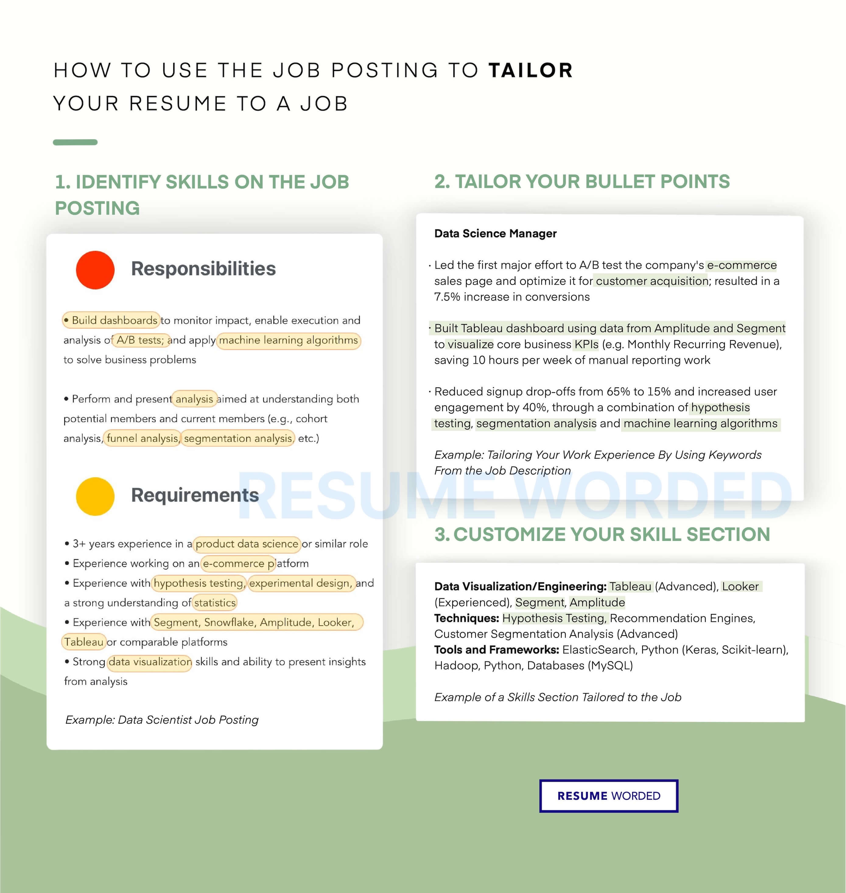
- Use the job posting as a guide. Check the job posting and list hard skills mentioned in the description
- Group your skills by proficiency level, like Advanced vs Familiar or Expert vs Working Knowledge.
Here are some guidelines you should avoid:
- Avoid listing the same hard skills on every resume regardless of the specific job you’re applying for (especially if you’re changing careers)
- Avoid mentioning hard skills that aren’t relevant to the job
- Don’t list every single skill you’ve ever dabbled with
- Don’t list skills you aren’t comfortable using in a professional setting
- Don’t: Use fancy images or infographics — stick to text only on your resume.
How to list hard skills on a resume
There are a few optimal ways to list hard skills on your resume:
- In a dedicated skills section
- In a general ‘other’ section
- In your work experience
- In a resume summary
Skills section
Because hard skills are objective, you don’t need to elaborate on them unless you feel it’s necessary. A simple skills list is enough to bypass ATS and allow hiring managers to quickly skim your resume for key skills.
If you have a lot of skills and your skills section is starting to get cluttered, consider using subheadings to separate your skills section into different categories — for example, technical skills, techniques, software, languages, or certifications.
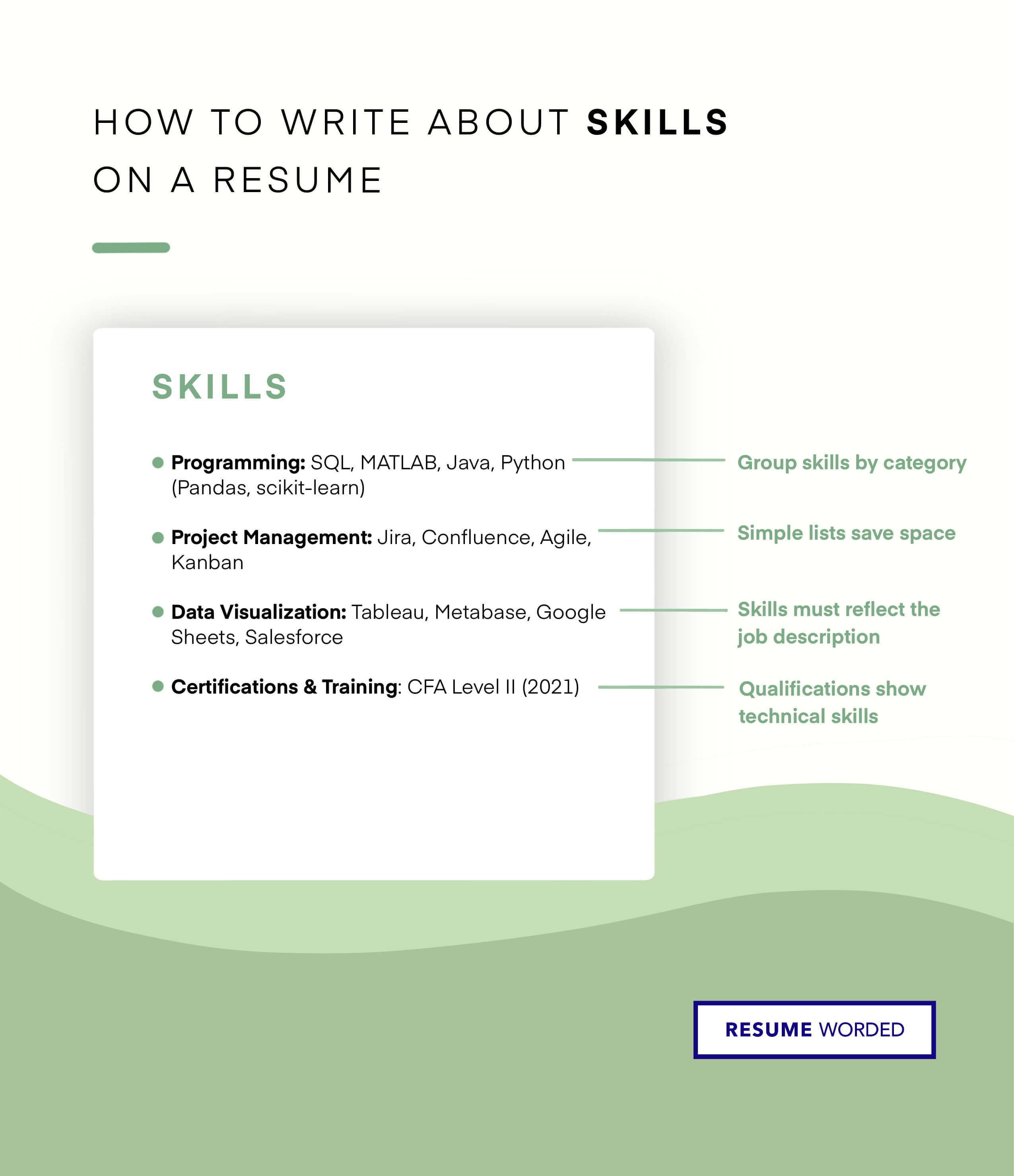
What to call it: Skills or Technical Skills
Where to put it: At the end of your resume
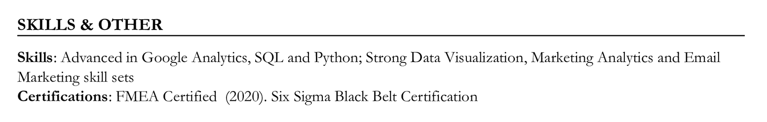
Additional information section
If you only want to list a small number of key skills, you can combine your hard skills with other information like projects, awards, and community involvement. Make sure you mark your skills clearly with their own subheading — most recruiters only spend a few seconds on an initial resume scan, so you want them to be able to find important information at a glance. List clearly marked hard skills in an ‘other’ or ‘additional information’ section
SKILLS & OTHER
Skills: Advanced in SQL, Python, and Jira; Strong practical experience with Business Intelligence tools, like Tableau and Cognos
Volunteering: Volunteer 20+ hours a month at ABC Foundation, leading data science projects.
What to call it: Other or Additional Information
Where to put it: At the end of your resume
Work experience
While a simple skills list is fine, listing hard skills in your work experience takes it a step further by showing how you’ve used those skills in a professional setting. Use your bullet points to list accomplishments related to the hard skills you most want to emphasize, and don’t forget to use metrics to show the benefit those skills had to your company.
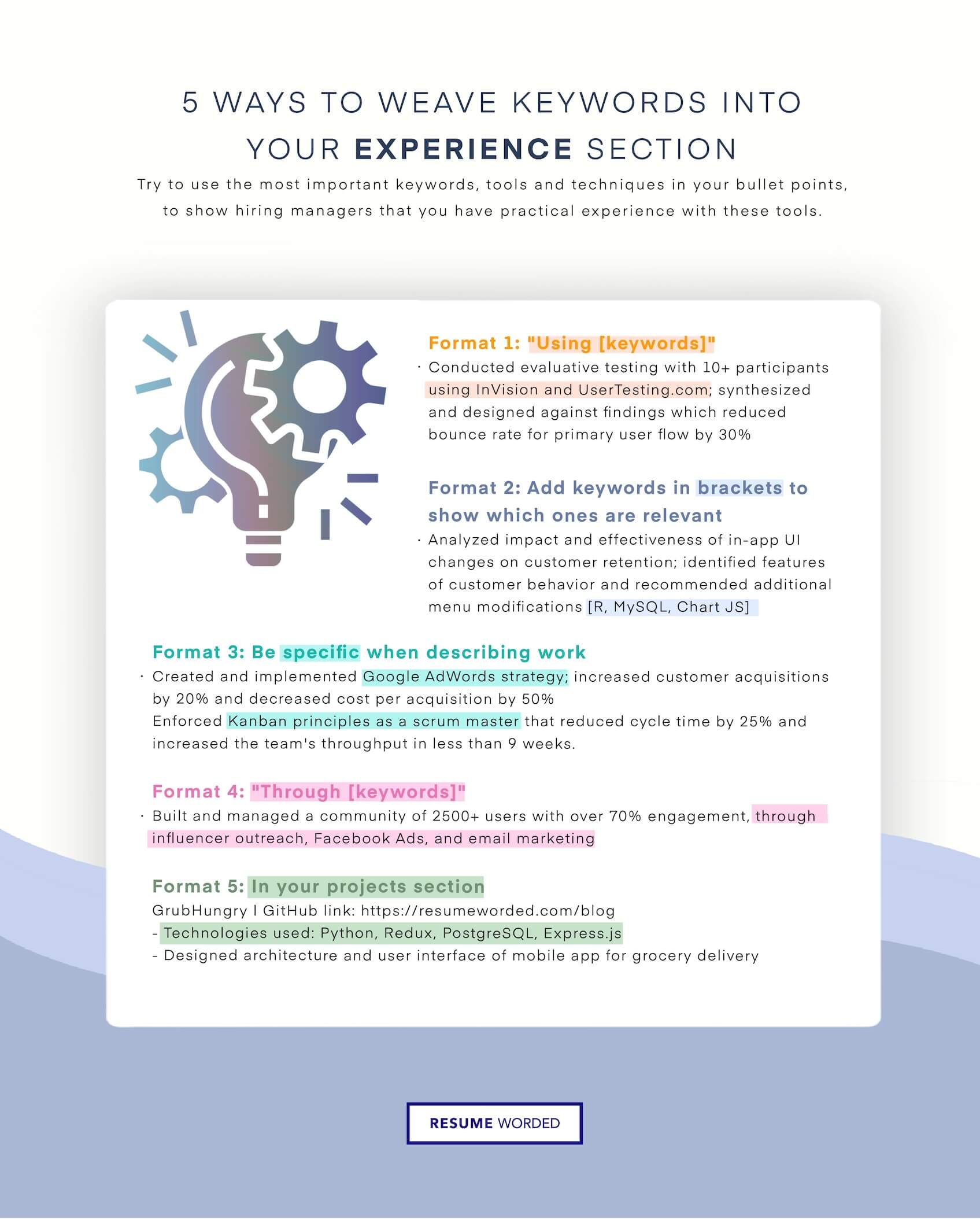
Here are some more examples you can use to get started:
- Cut projected time for data analysis by one week by developing reusable ETL components using Pentaho Kettle.
- Designed, executed, and optimized digital marketing campaign on Google AdWords; led to 20% increase in ROI.
- Spearheaded the migration to Quickbooks ultimately saving the company over $200,000 annually in costs.
- Created Word macro to increase productivity when making policy mockup up to 75%
- Designed 6 company logos utilizing Adobe Photoshop and Apple Aperture software.
What to call it: Experience or Work Experience
Where to put it: At the top of your resume, underneath your contact information and resume summary (if you have one)
Resume summary
A resume summary is optional, but it can be a good way to highlight your most relevant skills and experience. Stick to 1-3 hard skills that are essential to the position you’re applying for and keep it to no more than a single short paragraph.
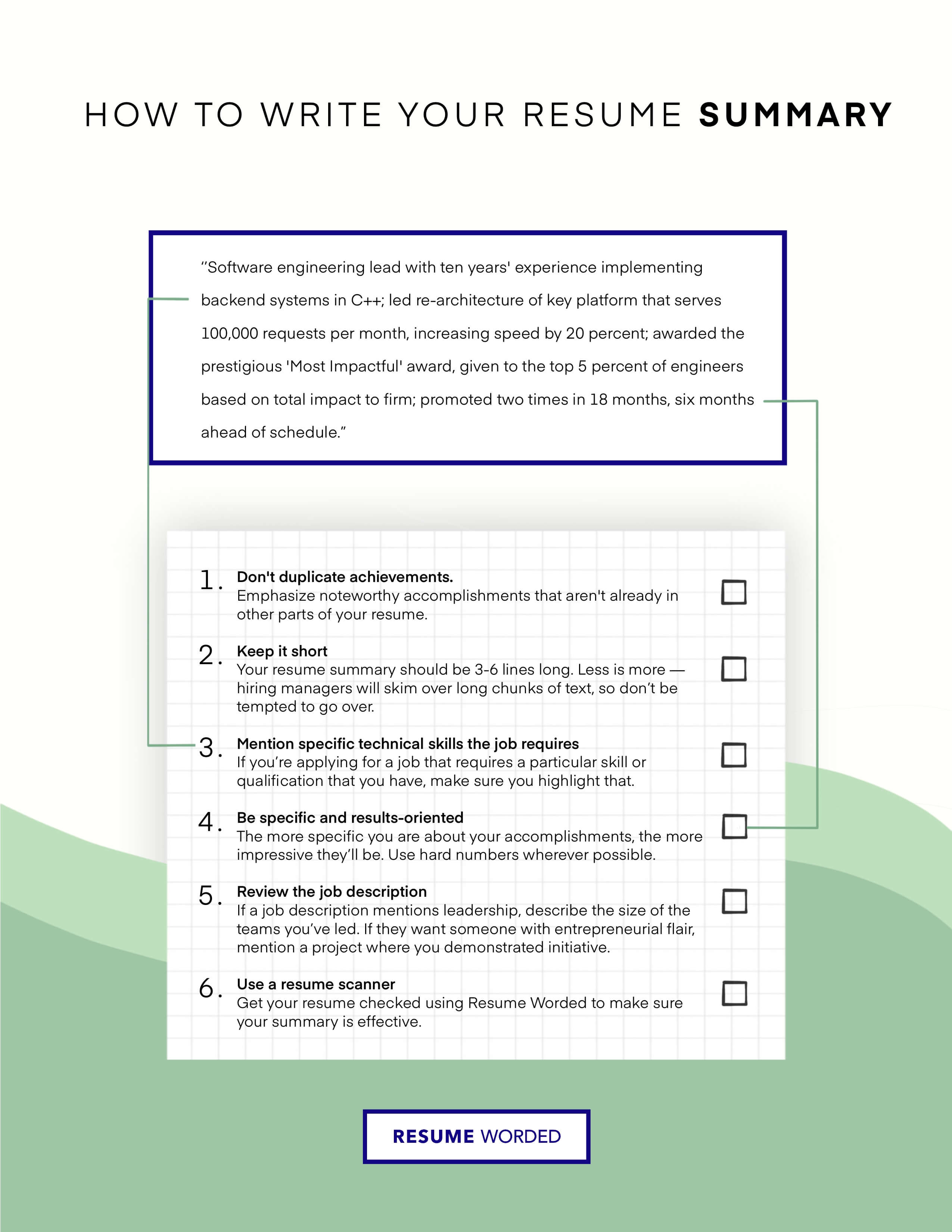
Here’s a resume summary template you can copy and paste:
[Job title] with experience leading [industry] businesses [describe size of businesses]. [Describe impactful element of role, with specific numbers]. Proven experience [mention 2-3 skills that are relevant to the job]. [Optional: Describe relevant educational certification/accomplishment, or one significant accomplishment in the format of Action Verb + Accomplishment + Metric].
What to call it: Summary (you can also choose not to label it at all)
Where to put it: At the very top of your resume, underneath your contact information
How to find relevant hard skills
Here’s a quick step-by-step guide to making sure you’ve included the most essential skills on your resume:
- Look at the job posting and add any skills mentioned in the job description.
- Type your job title, industry, or keyword(s) into the search bar on the left to get a comprehensive list of the top industry skills and keywords.
- Use a free online resume scanner to optimize your resume and suggest missing skills and keywords.
Browse Skills and Keywords in Popular Jobs
You can also search for a specific job on the left, or browse through the list below. Choose the job that your role aligns closest to and see the skills and keywords you should include.
Financial Advisor
See Skills
Teacher
See Skills
Editor
See Skills
Architect
See Skills
Web Developer
See Skills
Auditor
See Skills
Web Designer
See Skills
Photographer
See Skills
Journalist
See Skills
Relationship Manager
See Skills
Network Manager
See Skills
Social Worker
See Skills
Psychologist
See Skills
Development Engineer
See Skills
Webmaster
See Skills
Copywriter
See Skills
Librarian
See Skills
Plant Manager
See Skills
Portfolio Manager
See Skills
Pharmacist
See Skills
Animator
See Skills
Teller
See Skills
Mechanic
See Skills
Personal Trainer
See Skills
Electrician
See Skills
Dentist
See Skills